
Pittsburgh sits on steep hills and narrow valleys. Many homes perch above rivers or along hillside streets. The views can look amazing. However, building on sloped land takes careful planning. Soil can move. Slopes can shift. In some areas, landslides can happen after heavy rain or ground changes. Because of this, many property owners start with a topographic survey before building. This survey shows the true shape of the land. It also helps engineers and builders understand slope conditions. As a result, projects can move forward safely.
If you plan to build on hillside land, learning how a topographic survey works can help you avoid costly mistakes.
Why Landslide Risk Exists in Parts of Pittsburgh
Pittsburgh developed on steep terrain. In fact, many neighborhoods sit on hillsides shaped long before homes and roads arrived. Over time, construction changed the land. Cuts in the hillside, road grading, and older development all affect slope stability.
At the same time, the soil in western Pennsylvania often contains clay. Clay holds water. When the ground becomes saturated, the soil can weaken. Then the slope may slowly shift.
Weather also plays a role. During the winter, freezing and thawing cycles push the soil apart. Later, spring rains add moisture to the ground. These changes can cause slow movement along a hillside.
Because of these conditions, land that looks stable may hide deeper problems. That is why a topographic survey often becomes the first step before development.
Signs That a Hillside Property May Be Unstable
Sometimes a hillside shows small warning signs before bigger problems appear. Because of this, property owners should pay close attention to what the land is doing.
For example, trees on unstable slopes often lean downhill. In other cases, tree trunks bend as they grow upward again while the ground slowly shifts beneath them. Cracks may also appear in soil, sidewalks, or pavement. These changes can happen gradually, so they are easy to overlook at first.
Retaining walls can also reveal trouble. If a wall begins to tilt, bow outward, or separate from the soil behind it, the ground may be pushing against it. Likewise, small gaps near foundations or along the edge of a driveway may suggest the soil is moving.
Even small changes in the ground matter. A slope that moves slowly today can lead to larger problems later. Because these signs can be difficult to notice early, many property owners decide to have a topographic survey done on their hillside property so they can better understand how the land slopes and where movement might occur.
By seeing the terrain clearly, property owners can make smarter decisions before starting construction or development.
What a Topographic Survey Shows About Hillside Land
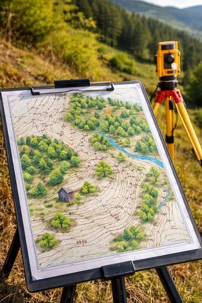
A topographic survey maps the elevation and shape of a property. Surveyors measure the land using precise equipment. Then they create a detailed map that shows contour lines, elevation points, and surface features.
Contour lines reveal how steep the slope is. Close lines show steeper terrain. Wider spacing shows gentler slopes.
The survey also identifies important land features. These can include trees, retaining walls, driveways, and natural ridges. Even small dips or rises appear on the survey map.
Because of this information, engineers and designers gain a clear picture of the hillside. Instead of guessing the slope, they see the exact shape of the land.
How Survey Data Helps Evaluate Landslide Risk
A topographic survey does more than draw a map. It gives engineers valuable data about slope behavior.
First, the survey shows the angle of the hillside. Steeper slopes often require extra design care. Engineers can review the elevation data and decide where building works best.
Next, the survey highlights areas where soil may collect water. When water gathers in certain spots, it can weaken the slope. Identifying these areas early allows designers to adjust the project.
Finally, the survey helps teams see how different parts of the property connect. One section of land may sit higher or lower than expected. Even small elevation changes can affect stability.
With accurate measurements, engineers can study the slope before construction begins.
Why Early Survey Data Matters for Development
Starting a project without clear land data can lead to expensive surprises. For example, builders may place a structure where the slope cannot support it. Later, they must redesign the foundation or move the project entirely.
However, a topographic survey provides reliable information from the start. Designers can plan buildings around stable areas of the property. They can also adjust layouts to match the terrain.
Early survey data also helps project teams coordinate better. Architects, engineers, and contractors all work from the same information. As a result, fewer changes appear during construction.
This approach saves time, reduces risk, and keeps projects moving forward.
Situations When Pittsburgh Property Owners Need a Topographic Survey
Not every property requires the same level of planning. However, hillside land often benefits from careful evaluation.
Many property owners order a topographic survey when purchasing undeveloped land. This helps them understand whether the site supports future construction.
Others request surveys before building additions, garages, or driveways on sloped lots. Even smaller projects can affect hillside stability.
Developers also rely on surveys when planning townhomes or subdivisions. The elevation data helps determine road placement, building locations, and safe construction zones.
Because each hillside property differs, a survey provides clarity before work begins.
How Surveyors Collect Topographic Data
Licensed surveyors gather measurements directly on the site. They use specialized tools that capture precise elevation points across the property.
Survey equipment records the height of the ground at many locations. Then the surveyor connects those points to form contour lines and terrain models.
In some cases, surveyors also use drones or advanced mapping tools to collect data across large areas. These methods allow surveyors to capture detailed information about complex terrain.
After the field work ends, the surveyor prepares a map that shows the property’s elevation patterns and surface features.
Why Hiring a Licensed Land Surveyor Matters
Accurate elevation data requires professional experience. A licensed surveyor understands how to measure land precisely and interpret terrain conditions.
In addition, surveyors follow strict standards that ensure reliable results. Builders and engineers depend on this accuracy when designing structures on sloped land.
Working with a licensed professional also helps property owners avoid errors. Incorrect measurements can lead to costly redesigns or unsafe construction decisions.
Because of this, hiring a qualified surveyor remains an important part of any hillside development project.
Final Thoughts
Pittsburgh’s hills give the city its character. However, hillside land also brings unique challenges. Slopes can shift over time, and soil conditions may change with weather and development.
A topographic survey helps property owners understand these conditions before building. The survey reveals the true shape of the land and provides the elevation data engineers need to evaluate slope stability.
With accurate survey information, project teams can design safer structures and avoid costly surprises. For anyone planning to build on hillside property, starting with a topographic survey creates a stronger and more confident foundation for the entire project.